Case study

Urban expansion insight – Sustainable development goal indicator 11.3.1 reporting made easy

Project duration
2023-2024
Project area
Global, across all world regions
Customer
UN-Habitat, national and local city authorities in developing countries

Situation

Sustainable urbanization presents both a global challenge and an opportunity.

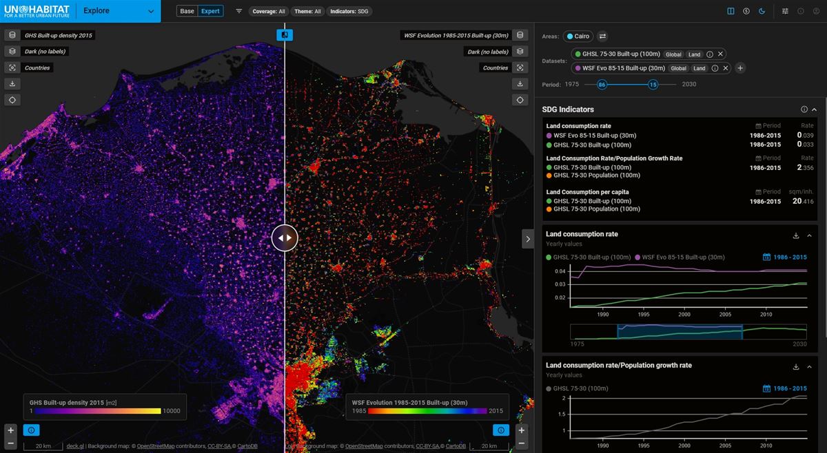
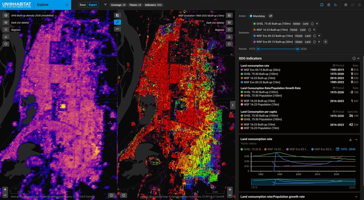
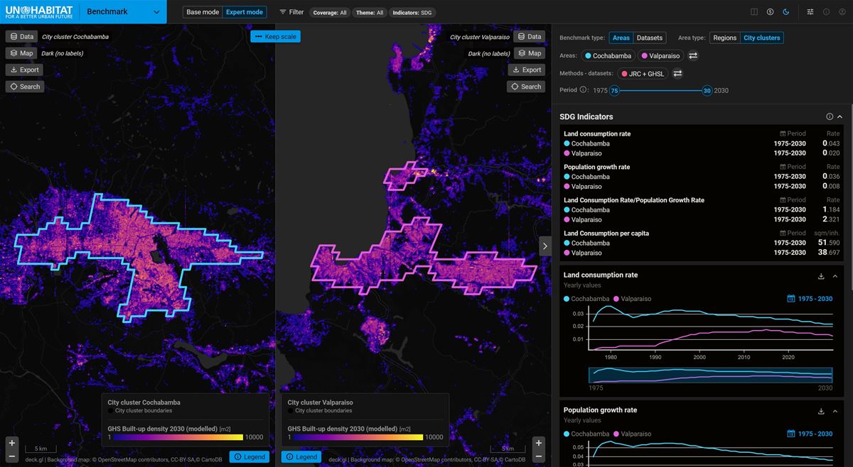
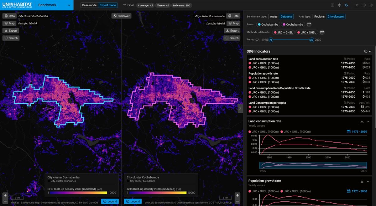
While Earth Observation (EO) technology offers impressive capabilities to deliver high-quality, spatio-temporally rich, harmonized, and fit-for-purpose data essential for understanding the built environment and long-term urban development, its full adoption for operational activities is often hindered. The process of creating, handling, and exploring vast global datasets on built-up areas, defining analytical units, and generating standard indicators can be tedious and complex, complicating or even preventing the practical uptake of EO potential. There is a critical need for quality, harmonized, and relevant data to effectively navigate urbanization processes for the benefit of all.

This initiative was motivated by aim to leverage opportunities presented by existing technologies, such as UrbanTEP (including VISAT and EuroDataCube), and a new generation of global urban datasets, like Global Human Settlement Layer (JRC) and specifically the World Settlement Footprint (WSF) suite, to address these obstacles and improve the situation with dedicated analytical web application. The cooperation was funded by ESA Earthnet, supporting collaboration with UN-Habitat on Sustainable Development Goal (SDG) 11 ("Sustainable cities and communities") and the New Urban Agenda (NUA).

Solution

Gisat has decades of experience in developing intuitive web-based platforms for geospatial analysis

These are built on our proprietary advanced open-source framework. We are recognised experts in applying global open Earth Observation data for urban monitoring, including support for SDG indicator reporting.

The Urban Expansion Insight application simplifies the exploring and analysis of available global  urbanisation data and thus facilitates operational use of EO for global sustainability agendas. It supports UN-Habitat, national governments, and local uthorities—particularly in developing countries—by delivering actionable insights aligned with SDG Indicator 11.3.1 for both administrative and functional urban areas.

Key Modules and Features include:

Explore Module, which enables users to flexibly examine urbanisation trends globally, combining built-up and population data across different timeframes and scales.

Benchmark Module, which supports rapid comparisons between countries, regions, and city clusters, helping assess disparities and progress over time. At the same time, it supports benchmarking across global urban datasets, allowing users to assess how differences in data quality influence key indicators and the messages derived from them.

Report Module allows users to generate tailored reports, including maps, indicators, and insights, for policy or planning needs.

Together, these modules offer an integrated, user-friendly solution that turns EO data into strategic intelligence for better urban planning and management worldwide.

Results

The Urban Expansion Insight application directly contributes to the production of high-quality data on SDG indicator 11.3.1, worldwide

It also prepares the ground for monitoring other related indicators within the New Urban Agenda (NUA) framework.

A significant outcome is the tangible support provided to national and local city authorities, particularly in developing countries. The application empowers them to embrace EO technology in their work, effectively monitor and analyze their urbanization processes, and report on SDG indicator 11.3.1 on sustainable urbanization.

The project yields several key benefits:

For End Users: It allows UNHabitat (as Custodian Agency for SDG Indicator 11.3.1) and supported countries to "focus on the problems to be solved and solutions, not on technical obstacles," fostering greater awareness and confidence in using EO datasets.

For the Research Community: It promotes the use of "the right data for the right purpose" and provides "more evidence about the strengths and limitations of individual datasets".

By simplifying access to and analysis of complex global urban data, Urban Expansion Insight helps bridge the gap between advanced EO capabilities and practical operational activities, accelerating progress towards global urban sustainability goals.